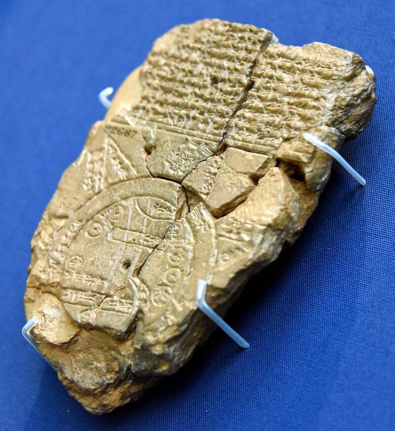
The Imago Mundi is a 3,000-year-old Babylonian tablet believed to be the oldest world map. Created around the 7th century B.C.E., it shows how ancient Mesopotamians viewed the Earth. The map focuses on the Euphrates River and includes cities, mountains, and other local features.
The cuneiform writing on the tablet describes how the god Marduk created the world and tells of King Utnapishtim, who built a huge ark to survive a great flood—a story similar to Noah’s from the Bible. Recently, researchers decoded more of the text that had puzzled experts for years, and they now believe it may reveal where Noah’s ark is located.
History Of The Oldest Map
In 1882, the British Museum acquired the tablet, found in southern Iraq near the ancient city of Babylon. It was 3,000 years old and showed a map of Mesopotamia, including Babylon, the Euphrates River, and other landmarks. The tablet was named the Imago Mundi.
The map is encircled by a double ring known as the “Bitter River,” beyond which lay unknown lands to the Babylonians. Triangles outside the river possibly represent faraway mountains or unexplored regions.

Dr. Irving Finkel, a curator and cuneiform expert at the British Museum, explained in a video, “You have encapsulated in this circular diagram the whole of the known world in which people lived, flourished, and died. However, there’s more to this map than that.”
Recently, Finkel and other researchers translated additional cuneiform text, and it seems to hint at the location of Noah’s ark.
New Discoveries About Noah’s Ark
One inscription on the Imago Mundi directs travelers going to the fourth triangle on the map to journey seven leagues until they find “something thick as a parsiktu-vessel.” A “parsiktu” is a rare word that refers to a specific type of boat, most famously mentioned in the Babylonian flood story, which parallels the Biblical Noah’s ark.
In Mesopotamian mythology, Utnapishtim built an ark in 1800 B.C.E., which eventually rested on a mountain called Urartu. Many Biblical scholars believe Urartu is the same as Mount Ararat, where the Bible says Noah’s ark came to rest. The Imago Mundi seems to indicate that the ark’s location is near the fourth triangle on the map.

“That’s quite a meaty thing, quite an interesting thing to think about because it shows that the story was the same, and of course, that one led to the other,” Finkel said.
Today, the Imago Mundi tablet is displayed at the British Museum, where it continues to reveal insights into how ancient people understood their world. Each new finding deepens our connection to a civilization that mapped their world while blending in their cultural beliefs. It’s incredible that thousands of years later, we’re still uncovering new details.


