A map of Germania from the 2nd century created by the Egyptian-Greek scholar Ptolemy has puzzled scholars for centuries, as they have been unable to match many of the mysterious locations on the map to known settlements.

Recently, a group of researchers based in Berlin have successfully deciphered the code and discovered that half of Germany’s cities are at least 1,000 years older than previously thought.
Claudius Ptolemy
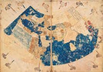
Claudius Ptolemy, an Egyptian-Greek scholar, lived during the 2nd century AD in Alexandria. He was an expert in astronomy, mathematics, and geography, and his ideas greatly influenced medieval astronomy and geography. His impressive world map, included in his work Geography, was the first to use longitude and latitude lines, and it was published in the 2nd century.
Ptolemy primarily based his maps on maps and records from 1st-century AD sailors, but he was skeptical about their accuracy. He also used other sources that have not been identified, as well as recent information, particularly regarding the Asian and African coasts of the Indian Ocean. He likely also consulted specialist literature on astronomy and geography that was available at the Great Library of Alexandria.

Ptolemy is renowned for his geocentric model of the Universe, known as the Ptolemaic System. He outlined this model in Book XIII of his Great Thirteen Volume Work, also known as the Almagest. Despite some inaccuracies, Ptolemy made several accurate observations, which even Isaac Newton couldn’t replicate with the instruments he had available.
In his treatise “Astrological Influences,” Ptolemy expressed his conviction that astrology is a valid science, which explains the impact of celestial bodies on life on Earth.
Ptolemy’s geography
Ptolemy’s Geography, written around 150 AD, was an eight-volume atlas containing 26 maps in colored ink on animal skin. Unfortunately, the original maps have been lost and only copies of the index remain. These were often reproduced by hand, but the maps were not always redrawn during the copying process.
Today, the majority of existing copies do not include Ptolemy’s original drawings, instead, they include maps made hundreds of years later based on his descriptions. However, scholars have been able to reconstruct Ptolemy’s maps by using the longitudes and latitudes from his index. Ptolemy’s map provides a clear and detailed picture of the world as it was known by a resident of the Roman Empire at its peak.
Ptolemy’s Geography covered a vast area, from the Shetland Islands in the north to the sources of the Nile in the south, from the Canary Islands in the west to China and Southeast Asia in the east. He believed that the known world covered about a quarter of the earth’s surface, which is relatively accurate compared to other ancient texts and scholarly works, particularly those that were housed at the Library of Alexandria before its disappearance.
Ptolemy’s work
Ptolemy’s Geography was not widely known in the Western world for over a thousand years, but it was rediscovered in the late 14th century during the Renaissance period. It was translated into Latin, which was the language of Western scholars at the time. The work became popular once again, and over 40 editions were printed. The new edition caused a sensation and challenged the foundations of medieval maps at the time.
Prior to the rediscovery of Ptolemy’s Geography, map makers based the sizes of countries and cities on their perceived importance, rather than on mathematical calculations. This meant that the more important a country was considered to be, the larger it would appear on the map.
Ptolemy’s Geography is an impressive accomplishment when considering that for over 1,500 years it was the most detailed topography of Europe and Asia available and the best reference on how to collect data and draw maps. The most genuine copy of Ptolemy’s map still in existence is an edition produced in the early 14th century (around 1300) and kept by the Vatican.
Recently, Ptolemy’s incredible atlas was the subject of a new study by a team of classical philologists, mathematical historians, and surveying experts at Berlin Technical University’s department for geodesy and geo-information.

The early history of most German towns east of the Rhine, an area not permanently occupied by the Romans, is largely unknown, and these towns are not mentioned in documents until the Middle Ages. Researchers from Berlin Technical University used Ptolemy’s Geography to create a map of Central Europe as it was 2,000 years ago, challenging the assumption that these cities date back no more than 500 years.
Ptolemy’s Germania Magna map depicted a territory that was likely unfamiliar to those living in Alexandria, Egypt. The map shows the area as being bordered by the Rhine in the west, the North Sea and Baltic Sea in the north, the Danube in the south, and the Vistula and Western Carpathian Mountains in the east.
Interestingly, Ptolemy listed 94 settlements in Germania Magna, despite the fact that the more easily accessible three provinces of Galia had only 114 settlements in total. Additionally, Ptolemy did not attribute any of these Germanic settlements to a specific tribal group, yet he accurately recorded their latitude and longitude to within a few minutes. This raises the question of where Ptolemy may have obtained his information about this unknown, non-Roman territory.
There is a significant issue when comparing Ptolemaic coordinates to modern geographic reference system coordinates, as they often show significant discrepancies. This can be attributed to a number of reasons, including the different “Zero Meridians” (Prime Meridians) used in the Ptolemaic and modern reference systems.
In addition to the differences in reference systems, there are also various errors in Ptolemaic coordinates. Furthermore, the majority of the place names in Germania Magna are not found in any other sources, and are only known from Ptolemy. As a result of these issues, it has not been possible to reliably locate even a few of the places mentioned on Ptolemy’s map of ancient Germania Magna. Despite providing the most comprehensive topographical description of ancient Germania, the inaccuracies and errors make it difficult to use as a reliable historical resource.
Ptolemy, a famous ancient geographer, did not take measurements in northern and western Europe, including the Germanic lands. Scholars believe he likely relied on lost Roman trader itineraries, sailors’ notes, or maps used by Roman military in northern Europe. The origins of ancient settlements in Germania have remained a mystery until now.
A team of experts in surveying and mapping, based in Berlin, has attempted to solve one of the mysteries of Ptolemy’s map of Germany Magna. The team spent six years examining the data on Ptolemy’s map, and developed a method called “geodetic deformation analysis” to correct any errors. As a result of their work, the team was able to locate the hometowns of the legendary Germanic figures Siegfried and Arminius to within a range of six to twelve miles.
The team also published a book titled “Germania and the Island of Tula” about their project. While the Vatican’s copy of Ptolemy’s geography is believed to be the oldest, the team was able to obtain copies of parchment found at Topkapi Palace in Istanbul, Turkey, which was once the residence of Ottoman sultans. The valuable document consisted of unbound sheepskin pages with writing in Roman capital letters and is now believed to be the oldest known edition of Ptolemy’s work.
By utilizing the newly discovered map, the team found that even small German towns such as Saltscotton and Lalandorf have existed for at least 2000 years. They discovered that the location at the confluence of the Elbe and Alster Rivers was the precursor of Hamburg and that Leipzig was known as Arigalia at that time.
The team’s research shows that many German cities are 1000 years older than previously thought. Additionally, many of Ptolemy’s coordinates for ancient German settlements match sites where archaeologists have previously found Gothic or Teutonic houses and large tombs for tribal princes. This raises the question of what other secrets may be hidden in Ptolemy’s maps.