The first sign isn’t on a weather map. It’s that strange, metallic cold on your face when you step outside, the kind that bites deeper than the temperature on your phone seems to justify. Streetlights glow in a thin halo of ice crystals. You can hear the crunch of snow three houses away because the air is so sharp and dry it feels like glass.
Somewhere 30 kilometers above your head, the polar vortex is wobbling.
You can’t see it shifting, but the atmosphere is rearranging itself, like a giant chessboard in slow motion. Flights trace odd routes. Storm tracks hint at a new pattern. Meteorologists stare at pressure charts full of purple and blue, knowing what often comes next: cold shunted south, chaos spilling out in waves.
A major disruption is brewing high above the Arctic right now.
And that’s when weather on the ground stops playing by the usual rules.
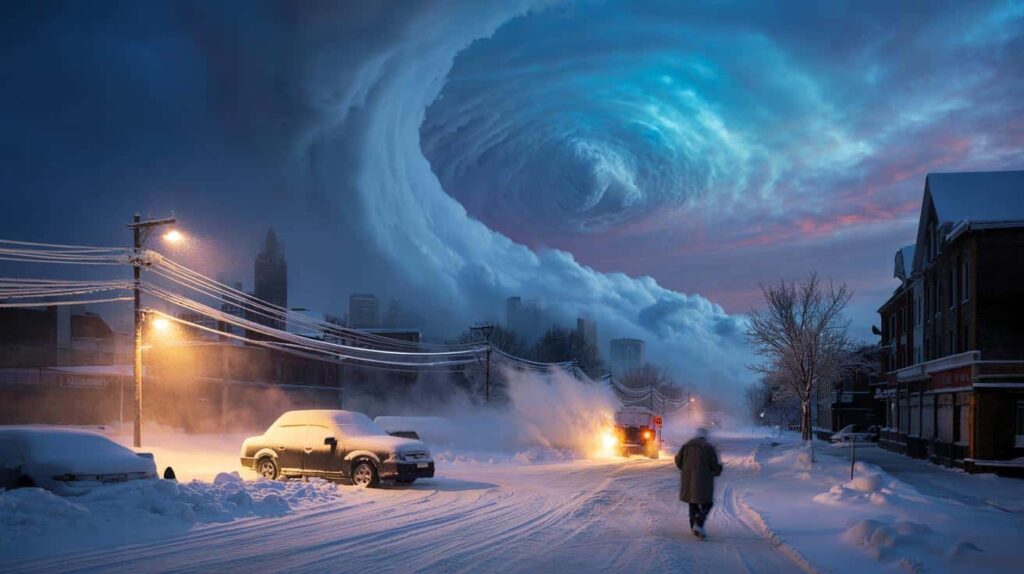
The polar vortex is cracking open — and the atmosphere is about to respond
Up in the stratosphere, roughly twice the cruising altitude of a jetliner, sits a spinning ring of frigid air that meteorologists call the polar vortex. Most winters, it’s a reasonably stable beast, corralling the cold around the pole like a fence. This year, that fence is bending and buckling.
Forecast models are flashing red for a significant “sudden stratospheric warming” event — a rapid temperature spike over the Arctic that can smash the vortex apart. When that happens, the cold doesn’t just stay put. It spills, slides and fractures its way south, riding the jet stream like a broken conveyor belt.
If that sounds abstract, think back to February 2021 in Texas. The polar vortex weakened, lobes of brutal Arctic air punched deep into the southern United States, and a state built for air-conditioning suddenly faced pipes exploding in unheated homes. Nearly 10 million people lost power. Roadways became luge tracks of black ice. That’s the kind of cascading hazard a disrupted vortex can trigger.
Similar stories unfolded in Europe in 2018 with the “Beast from the East,” when Siberian air collided with moist Atlantic systems and dumped snow over cities that rarely see a flake. These aren’t freak, once-in-a-century curiosities. They’re the downstream consequence of a delicate system jolted out of balance.
Here’s the basic logic, stripped of jargon. When the vortex gets hammered by warming high above, its winds can slow or even reverse. The jet stream, which helps steer storms, stops flowing smoothly west to east and starts looping and buckling. Those loops act like giant slides, sending Arctic air south in one place while letting mild air surge north in another.
That’s where the trouble begins. *Sharp temperature contrasts fuel storms.* A bitter air mass colliding with moist, relatively warmer air can spin up blizzards, freezing rain events and heavy snow bands that stall over the same region for days. One disruption high above the pole can echo through the atmosphere for weeks, knocking over weather dominoes clear across the hemisphere.
From ice storms to whiteout blizzards: how this disruption could play out on your street
For anyone on the ground, the polar vortex disruption won’t appear as “breaking news in the stratosphere.” It’ll arrive as a slow creep of weirdness in local forecasts. First, temperatures swing wildly — a mild spell, then a brutal drop. Then, the precipitation type starts to wobble between rain, sleet and snow in a way that makes commutes a gamble.
One of the most likely hazards in the weeks after a big disruption is freezing rain. A shallow Arctic layer at the surface, with warmer air just above it, can turn what would be a simple rain event into a glittering sheet of ice over roads, trees and power lines. That thin layer can be more dangerous than any picturesque snowstorm.
Meteorologists in North America and Europe are already eyeing patterns that favor “mixed bag” storms. Think of a system that starts as cold rain, flips to sleet, then dumps heavy, wet snow in a matter of hours. Cities sitting on the boundary between Arctic and subtropical air masses — places like Chicago, New York, Paris, Berlin — become prime candidates for these messy, high-impact events.
Imagine a weekday morning where the bus stop is wet pavement at 7 a.m., a slushy mess at 9 a.m., and a skating rink by lunchtime. School dismissals get moved forward in a panic. Delivery drivers crawl at walking speed. Hardware stores run out of ice melt before noon, because the last storm emptied everyone’s sheds.
Then there’s the blizzard side of the story. When cold air digs in and stays put, it can lock horns with an approaching storm track. That’s when you get the classic nor’easter along the U.S. East Coast or a deep, slow-moving low over central Europe, funneling wave after wave of moisture into sub-freezing air. Visibility plunges. Snow drifts swallow cars. Rural communities can go quiet for days, pinned under white and wind.
Scientists talk about this in terms of teleconnections and anomalous geopotential heights. On the ground, it just feels like winter on fast-forward. One big disruption offshore in the stratosphere, then a cascade of alerts: ice storm warning, blizzard warning, avalanche risk, river levels on watch as snowmelt timelines get scrambled. The atmosphere stops behaving like a smooth conveyor belt and starts acting like a pinball machine.
Staying one step ahead when the atmosphere goes off-script
There’s no way to “stop” a polar vortex disruption, but you can ride out its ripple effects with fewer nasty surprises. The first step is tracking patterns, not single forecasts. When meteorologists start mentioning **sudden stratospheric warming**, that’s your cue to zoom out from the 24-hour outlook and pay attention to the next 10–20 days.
On a practical level, treat the upcoming weeks like a weather wildcard round. Keep a basic cold-weather kit ready: a small stash of bottled water, shelf-stable food, extra blankets, a flashlight with fresh batteries, and power banks charged for your phone. It sounds basic, almost boring. Then the lights go out in an ice storm and those tiny preparations suddenly feel like superpowers.
The emotional part is trickier. Disrupted winters mess with routines. School closures, delayed flights, canceled shifts — they don’t just inconvenience, they chip away at a sense of normal. We’ve all been there, that moment when a simple grocery run turns into a white-knuckle drive home on black ice.
Let’s be honest: nobody really checks their local hazard maps or emergency plans every single day. That’s why this kind of pattern change is a good excuse to reset the autopilot. Talk with your household about who does school pickup if the storm hits early. Ask elderly neighbors what they’d need if they got snowed in. These small conversations spread the weight around a bit, instead of leaving everyone to scramble alone.
Sometimes, hearing it straight from experts helps cut through the noise and alarmist headlines.
“People hear ‘polar vortex’ and think it’s some new monster,” says a senior forecaster with a major European weather service. “It’s not new. What’s different is that we can see its disruption coming sooner — and the atmosphere’s response can be stronger when the background climate is warmer.”
To translate that into daily life, focus on a few simple pillars:
- Follow updates from a trusted national meteorological agency, not random social posts
- Prepare for power outages during ice events: charge devices, have candles or battery lamps, know how to manually open your garage
- Drive less when forecasts mention freezing rain or whiteout conditions; if you must travel, reduce speed dramatically and keep extra distance
- Layer clothing and keep a dry backup set at work or in the car for surprise snow or slush
- Think about vulnerable people around you: check in before, not after, a major storm
These aren’t heroic measures. They’re quiet, boring steps that often decide who shrugs at a storm and who ends up in real trouble.
What this winter twist tells us about a changing planet
A disrupted polar vortex is more than just a juicy headline for weather geeks. It’s a reminder that our atmosphere works as one enormous, interconnected system. Warm phases in the Pacific, snow cover in Siberia, sea-ice levels in the Arctic — they all tug on the same invisible threads that shape your local forecast. When one piece shifts hard, like the vortex breaking apart high above the pole, the rest of the tapestry pulls and bunches in unexpected places.
Some scientists suspect that a warming Arctic may be making these disruptions more frequent or more impactful, though the debate is still far from settled. What’s clear is that extremes love company: intense cold outbreaks can sit side by side with unusual warmth just a few thousand kilometers away, each feeding off the same warped jet stream. That’s why social feeds in the same week might show bikini shots from one country and blizzard videos from another.
This winter, as the vortex stumbles, your experience of it will probably be personal, not planetary. Maybe it’s an extra day working from home because of an ice storm. Maybe it’s a train that never arrives. Maybe it’s just that eerie silence of a city buried under fresh snow, where the usual hum is replaced by the muffled crunch of footsteps.
Yet behind those small, lived moments is a story reaching from your street right up to the edge of space. The cold wind on your face, the flicker of the lights in a freezing rain, the scramble to shovel out before work — they’re all little signatures of a high-altitude drama most of us will never see.
This might be a good time to ask: how ready are we, really, for a climate where “normal winter” becomes the exception and wild swings become the rule? And what stories will you remember from the day the polar vortex, invisible and distant, suddenly dropped a piece of the Arctic on your doorstep?
| Key point | Detail | Value for the reader |
|---|---|---|
| Polar vortex disruption | Sudden stratospheric warming can weaken or split the vortex, sending Arctic air south | Helps explain why extreme cold or snow can hit unexpectedly in mid-latitudes |
| Cascading hazards | Sequence of ice storms, blizzards, power outages and travel chaos over several weeks | Encourages planning beyond a single storm and thinking in terms of patterns |
| Practical preparation | Simple kits, communication plans and travel adjustments during volatile periods | Reduces risk, stress and disruption when the atmosphere goes off-script |
FAQ:
- What exactly is the polar vortex?
It’s a large-scale circulation of very cold air high above the Arctic (and Antarctic) in the stratosphere, spinning like a giant atmospheric hurricane around the pole. Near the ground, we only feel its influence when that circulation weakens or shifts, allowing Arctic air to spill south.- Does a polar vortex disruption always mean record cold where I live?
No. A disruption changes the odds and patterns, not a guaranteed outcome for every region. Some areas see brutal cold and snow, others end up milder than normal, depending on how the jet stream loops set up over your part of the world.- How long after a disruption do we see impacts?
Typically, the surface impacts show up 1–3 weeks after a major sudden stratospheric warming. The effects can linger for several weeks, with waves of storms and temperature swings rather than a single dramatic day.- Is climate change making polar vortex events worse?
Research is ongoing. Some studies suggest a warming Arctic may favor more frequent or intense disruptions, others are more cautious. What’s clearer is that a warmer background climate can load the dice for stronger moisture-laden storms when cold air does arrive.- How can I follow reliable updates about this disruption?
Look for national meteorological services, reputable weather agencies and established climate scientists on official channels. They often share clear, jargon-light explanations when the polar vortex is acting up, along with concrete guidance on expected local impacts.